
Iraqi Maritime Claim Unites Gulf Countries in Opposition
The registration by Iraq of a claim to maritime areas in the northern Gulf has generated an unusually quick and united rejection from the member states of the Gulf Cooperation Council.
At the heart of the dispute is a stretch of water between Iraq and Kuwait, which leads to Iraq’s main deep sea port at Umm Qasr. Since UN Resolution 833 passed unanimously in 1991, after the first Gulf War, the land borders in the area have been settled, and that the median line in the middle of the Khor Abdullah waterway between the two countries is the de facto border. This permits both countries to use the Khor Abdullah channel to service their land areas.
With Umm Qasr is served by this shared channel, Iraq’s other port at Basra also sits on a shared waterway, with the other side of the Shatt al Arab is owned by Iran. With both ports therefore somewhat vulnerable to interdiction in times of tension, Iraq is understandably keen to cement and consolidate its sea access for the future.
However, in seeking to secure this objective, Iraq appears to have gone about the task in a counter-productive manner. The maritime coordinates submitted by Iraq to the UN, in accordance with UNCLOS, create two areas of conflict.
The Iraqis are now claiming two shoals just off the eastern tip of Kuwait’s Bubyan Island as being Iraqi territory. If the Iraqi claim to Fasht al Qaid and Fasht al Aij is maintained, the median line in the Khor Abdullah could be pushed to the west in a manner which would restrict Kuwait’s use of the waterway - of particular concern now that Kuwait has signed up with China to build a new container terminal on Bubyan Island. After the war of 1990-91, Kuwait is understandably particularly sensitive to losing even an inch of land to Iraq.
The other consequence is that with a fatter wedge of land at the northern end and top of the Gulf, the Iraqi continental shelf claim is broadened at its southern end, to the extent that it now overlays the Dorra oilfield – the sharing of which has only recently been settled, to the chagrin of Iran, after years of dispute between Kuwait and Saudi Arabia.
It is unclear why Iraq wishes to upset all its neighbors by submitting this new claim, particularly as current arrangements appear to work well, to neither side’s disadvantage. The cause may be part of a jockeying for position between rival parties in the newly-elected Iraqi parliament, which is still negotiating the formation of a new coalition based on the recent election results, and the appointment of a prime minister. The adoption of a more nationalist position on the Khor Abdullah issue, which could also be construed as favorable to Iran, may be part of the coalition negotiating process.
It is noteworthy that in all the statements published by governments on this issue in recent days, none were able to identify exactly where the disputed Fasht al Qaid and Fasht al Aij shoals are. As the disputed locations are poorly identified, TME notes that the below illustration is not precise or definitive. Poorly-drawn charts are themselves a potential source of conflict if treated as formal documents; the image below is not intended to be displayed as an authoritative depiction of the disputed claims, and is only an approximation.

that matters most
Get the latest maritime news delivered to your inbox daily.
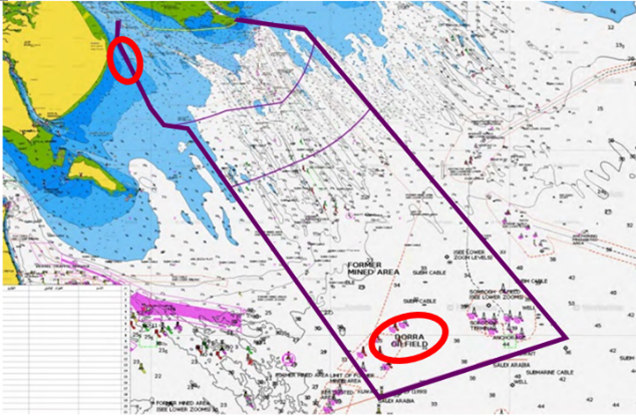
The Iraqi claim, with an approximate notation of the two areas of dispute it creates: the shoals off the eastern tip of Bubyan Island and the extension of the Iraqi continental shelf area into the Dorra oilfield (Iraqi Government map submitted to the UN/CJRC)